
Nav Challenge 1
Authors
Team Effort
01 September, 2021 - Graham K. Bushe
Adam likes orienteering, I like running. Adam has a hectic hurling and coaching schedule at this time of year ….. and tight calves, so the promise from me was we’d do the short course, hiking most of it.Nav Challenge races are great (I say this, having only done 2!) But they are. I love the calm atmosphere, relaxed start, not having to zoom off at next to full tilt keeping up with all the other gazelles. We were probably a little too laid back - Leaving the house about 15 minutes late!
Reaching Ballinagee Bridge, I found out we had a bit further to go to get to the parking area. Tick-tock Ah sure no worries… Park-up, wake Adam, sign in, all good. Get the gear ready. Backpack, Check! Maps & Compass, Check!, Food & Drinks, Check! Runners, -, Runners? – Erm – No! If it was Adam, he’d never have heard the end of it… So, it was to be my nice comfy (and well-worn) New Balance road runners. Oops! At least the carpark and fire road were lovely and dry. Good thing, because I also wear these at work!
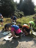
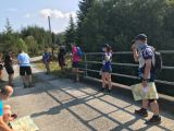
We headed to the start area full of eager anticipation of the adventure ahead. ( Well it may have been me full of the eager anticipation) As we walked anong, Adam spotted my punch card slip off my wrist, which wouldn' have been a great start. As we casually strolled neared the bridge, we saw a few people crouched over their maps, already busily marking and checking. Joe handed us our sheets and we set about marking our map. Using the East/West map Lugnaquilla & Glendalough, I had taken coloured scans and printed A4 sheets and placed them in plastic sleeves. I also carried the original map in my backpack. Controls 1,2,3,4 nice! We then talked a bit about route choice and decided that control #3 would be the best to start with. As we set off, I told Adam that I had passed this way during my Wicklow Round attempt. I also told him where I cut through on that attempt, rather than following the fire-road around. I then also showed him the exact spot where I felt the first wave of cramps on the Round. The poor lad, it was going to be a long day! Even if we were only doing the short course. Thankfully for both of us, we soon got back to the fire road and turning right, we had a light jog/walk and set about finding control #3. This was a nice find just off the side of the fireroad and set us up nicely. Next on the list, #1 The Ruin. Continuing as we were, to the river, then turning right. Mmm, some ‘soft’ ground I skipped as best I could over and around the boggy bits. Nicely done, until I landed in the middle of one! Ah well, they were wet then, so just get on with it! We punched the cards again and had a look to where #2 would be. We toyed with the idea of a direct route but looking at the youngish trees figured it would be too difficult to negotiate. We opted to go around and up. More boggy bits, more wet runners. The ground up along the fence seemed a bit rough so I had a brainwave to see if I could find an animal track a bit further out. I was delighted with myself when I did. Only to realise soon after that the ground was no easier and the growth was just the same. However. We soon found the control which made it 3 out of 4. One more and we’d be on our way back! Looking at the map we decided to continue on what bit of a path there was, and contour around to #4 “Sheep Pen”. On the way, we spotted a small flock of sheep. I asked them where their pen was, but they wouldn’t tell me. We could see other people heading in all sorts of directions. That’s another great thing about these challenges, you see others, but you don’t really know how far they have progressed, which route they’re taking etc. We got our last control . All done we had a little chat. I took out my compass, Adam said “Put that away”, so I challenged him. Right, you read your map, pick a direction, I’ll get my compass. We both pointed the same direction. And we set off. Soon after, I found a deer antler which we took as a souvenir, and soon after that we found a dead sheep. I didn’t take that! We found ourselves on a path of sorts which was not on the bearing we wanted but was easier going. We followed this uphill for a bit, and headed for the ridge. As we came to the top, we saw the fire road below and the river to the right. We decided to get to the river and follow it down. Getting back to the gate and out onto the hard surface, we decided to do a bit more jog/walk, after all his calves had gotten a good old stretching by that time. We trotted back to the bridge again, I checked the watch 2hrs (We may have started a tad late, which would explain the ‘few people’ we saw at the start. Ha ha).
We then went down to stand in the cool waters of the Kings river. Well, the runners were already quite wet and muddy by that stage. We then tucked into a couple of tasty bread rolls stuffed with sausages, prepared by Adam and a homemade chocolate milk that I carefully crafted that morning.
What a great way to enjoy the countryside, have fun, challenge myself, and spend time with Adam.
Thanks to Joe, Nora, Mick and Brian for a great day.
Hoping we can get to the next one, Wicklow East map bought already! :)
Nav Challenge 1 (2021) : Ballinagee Bridge Area
29 August, 2021 - Mike Jordan
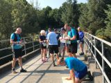
2 years since the last IMRA nav challenge and entrants were treated to a late August heatwave with clear skies and good visibility on it's belated return. Great to see familiar faces and there's always a great friendly informal vibe about these events. Start/Finish for the event was the bridge on the fireroad near Oakwood hostel with parking and registration further up the fireroad at the lay-by. 5 controls on the long course and 4 controls on the short course with manual wristband punchcards for each runner. Joe Lalor announced at about 10:20 that he was heading to the bridge to give a briefing and start the race. I was faffing a bit and took a few minutes to follow. I picked up a punchcard off the track and before long met Lorcan heading back in search of it. We strolled to the start and as we rounded the corner there was a flurry of activity on the bridge. Joe had already started handing out control sheets and started the race. I quickly grabbed a sheet and started marking my 5 controls. A quick double check of the required controls and their grid references and the controls formed an obvious loop that could be done clockwise or anti-clockwise. I quickly settled on anti-clock as it would allow me to do some route planning while running the flat first kilometre along Kevin's Way by the King's River.Control 1 was a ruin (marked with a red historical cross symbol and called a 'Booley' on the map) along the east side of the Glenree Brook. When Kevin's Way reached the bridge, I took the rough track uphill along the brook. The control was at a bend in the river but with plenty of bracken along the waters edge I kept my eyes peeled as I climbed. The kite was obvious on approach and I tagged it and continued up along the brook.
Control 2 was an old graveyard site above the forestry to the west of the brook but it didn't look like it would yield a straightforward route through so I crossed the brook and followed the fence on the outside of the trees. Some bashing through bracken initially but sticking close to the fenceline generally allowed safe passage. Kite was again easy to see from above but a slow escape through bracken followed.
Control 7 was a 3m boulder (called Big Rock of Coonty on the map). I took a quick bearing out of the control though from looking at the map I knew staying on the west side of the spur rising above the graveyard site should put me in the right direction. I saw Karen heading off further west and lower towards the sheep pen which was Control 4. A quick check of the control list to reconfirm it wasn't on the long course and then I continued plodding up through what was now rough heathery open mountain. There was a large boulder visible on my bearing from a long way off and I continued marching/stumbling until I reached the control. 3 controls done, 2 to go and I hadn't seen anyone ahead of me on my route so far. Having arrived late to the start I hadn't noticed if anyone had left before me while marking my controls but at this point I was confident there wasn't anyone ahead of me on the anti-clock direction.
Control 6 was the top of a small gully to the west of the waterfall on Asbawn Brook. Leaving Control 7 the view of the Glenreebeg valley opened up and I could see Asbawn rising out of the back of the valley. I decided to aim for the bowl at the foot of the brook and then handrail the river to make sure I didn't miss the control. It was risk averse compared to a high contour but I didn't lose too much height overall and found a few animal trods which allowed good progress at times. Initially I climbed on the east of the brook as I wasn't sure how passable the crag/cliff on the west would be but I soon spotted the control kite and grassy break near it on the other side and crossed over.
Control 5 was another 3m boulder (called Stinking Rock on the map!) located on the east side of the spur above White Hill (Oakwood on the Wicklow Round). I crossed Asbawn and headed directly for Art's Cross. As I reached Asnasluckan stream I met Maeve heading the opposite way. I reckoned this was the highest point on the route and potentially half the distance and this motivated me too not take it too easy. I followed the track from the cross southeast until it peters out, then took at bearing for Stinking Rock. I passed above the small crag (T045992) and crossed the faint trail along the spur. There were a lot of smaller boulders in the this area but the control site boulder was at a major change in slope angle and given as 3m in size. I dropped to the change in slope slightly south of where I expected the control to be and contoured it north until I spotted what looked like the largest boulder around. Tagging the control some indecisiveness set in, I started contouring towards White Hill with the intention of taking the most direct line possible to the finish but after a few minutes I chose to drop directly to the clearing at the felled forestry (O050007). This involved a 2.5k run along the fireroads back to the finish but had less rough open mountain to cross and meant I didn't need to try and find a way through the mature forest further west. Arriving at the finish Joe informed me I was first back on the long course.
A debrief and some chats before I headed off to see how Maike and Róisín had fared on the the short short course. A nice picnic in the shade of Tommy's van followed as runners finished over the next hour or so with their war stories of battles with bracken, bog and phantom boulders.
Thanks to Joe, Nora, Mick, Brian and Vivian for a fine morning out in the hills and well done to all the entrants.
Efficiency/Improvement: You can always do better on these challenges and there's never a perfect route. I had a good day and made good choices. The easiest way to look for improvement on a looped course is to look at the road not taken - the clockwise option. Reversing the route, I'd probably have done two legs differently. From the Start/Finish to Control 5, I'd have taken a more direct route up the 'Art O'Neill shortcut' to the upper fireroad and then gone up through the new forestry hoping to find the route used recently on the Wicklow Round to gain the top of the forestry. From here it would be rough going to gain the east side of White Hill and Control 5 but it would have definitely been the most direct route. From Control 6 to Control 7 I probably would have contoured high in an attempt not to lose the height I'd gained. Not as significant a time saving as the route from the Start to Control 5 but certainly one to consider.
Long Course:
Start/Finish Bridge 033020
Control 1 Ruin 024009
Control 2 Site of Cemetary 019007
Control 5 Boulder 3m 048995
Control 6 Top of Gully 030987
Control 7 Boulder 3m 018998
Map:
EastWest Lugnaquilla & Glendalough Map