
Nav challenge 1 Oakwood
Authors
Decision making and paying attention…
23 August, 2015 - Greg Byrne
The rain was incessant as the crowds gathered… any hopes that the lure of the duvet would have kept the numbers down were quickly dashed as I saw the cars lining the roadside. Setanta were well represented, many competitors having stayed on from their club champs the day before. 3Roc and CNOC colours were also visible. Add in the mist hanging around above 4-500m and it was going to an interesting day on the hills worthy of dissection post-race.We gathered outside the Oakwood hostel to hear Rachel introduce the two courses, both would take in three controls… and then the maps were released. Hands flashed and runners started to walk away, the navigators had their eyes down, the followers had their eyes open watching for first to break.
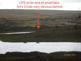
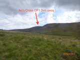
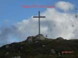
The start for the long course runners was to find a route out of the forest and onto the open ground below Art’s Cross (CP1). The obvious line was the traditional Art O’Neill route along the upper fire road and using the river side trails to get a position below the cross. Scanning the map showed this to be indirect, but offered very little choice other than one firebreak. As we emerged onto the upper road it was clear then the higher ground was newly forested… who would chance this? Conor Short lost some time, but was able to use the loss as motivation later (funnily I actually thought he was ahead throughout). I continued to the high point of the road and then entered the older wood, heading diagonally for the forest corner… good running until I hit the coillte log barrier… 50 metres deep and 5 trees high it was Tarzan territory. Should have stuck with the original plan! Making it out onto the open ground runners began to converge on the riverside trails. The recent rains were obviously running straight off the parched soil and meaning river crossings would need some careful choosing. The climb up to Art’s Cross is marked by an obvious fork in the river, some crossed early, some stayed left, but most seemed to follow Paul Mahon. The steep climb up brought the various routes and runners back together towards the top. Angus Tyner came from my right, Ben Mangan from my left and three of us trudged up the sodden slope. Angus emerged first and headed for three lakes.
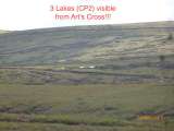
The thick mist, rough ground and various sheep tracks made for numerous route choices. In discussion afterwards it would have been possible to think everyone was in a different race, only the cross and the lakes seemed common to every different route. As it played out the first of the lakes provided a significant sign post and boosted the confidence as runners emerged from the various peat hags. CP2 was nicely placed in the sphagnum moss that encircles the smaller western lake.
From here the choices were numerous, but the mist and terrain combination meant the runners only tools was their map & compass. The route to CP3 was a gradual downhill, but the direct line would mean dropping into two valleys and losing precious height. My choice was a high contour and I set off on a bearing… shame I didn’t stick to it. The value of a GPS track is the ability to see ‘what you actually’ did… and my path wandered significantly as I followed any good running my limited visibility could catch. The fact I was dropping height made I easier to go off line. Sticking rigidly to the bearing would have kept me higher and possibly would have allowed me witness the fast moving group of four who used their mini-race to forge a significant advantage by the time they hit the CP3. As it was the mist cleared for 60 seconds to show the climb up to CP3 in front of me… Ooops, about 400m too far north of my desired line. Apologies to the wildlife in earshot, I may have uttered a few unmentionables.
Achieving CP3 brought back some confidence and I headed off on a NE bearing with the plan to re-orientate based on some features once I emerged below the mist. At this stage I had not seen another runner for about 30 mins. Emerging from the mist I saw the forest indicated in the map was no more and the fire road was visible, but so was the runner streaking down towards the finish. Who was it? Were they alone? So many questions… the answers would be at the finish.
It took about 8 mins to reach the point I had seen the runner, while there was about 4k to the finish it was good running and so it was time to jog home focused on no unnecessary detours. A quick glance right at the power lines showed no obvious route and so I hit St. Kevin’s way and followed it to the finish.
Coming into the finish I was greeted by Angus and quickly found out how much time my de-tour had cost. I doubt I could have stayed ahead of 4 runners battling across the heather, but staying higher may have allowed me to see them pass and the ‘invisible elastic’ might have allowed me stay in the race. Then again I am pretty sure I would make the same decisions/mistakes given the same conditions again.
In the end it was a great test, and great to have a team like Rachel, Paul & Co to organise such a race when most of the country are thinking they could bring the duvet to the couch for the football semi-final.
Well done to Conor for working hard and winning despite early wanderings. Well done to Niamh on taking the ladies long course. Also mightily impressed with everyone who collected controls in the conditions. Special mention must go to Keith Fitzsimmons taking second place on the short course… in wellington boots… how long until Inov-8 are doing a pair?
Introduction to Navigating on Water
23 August, 2015 - Lorcan Farrell
8:20am, Sunday morning, alarm going off, rain pounding at the bedroom window, do you, (A) roll over and go back to sleep, or (B), get out of bed, drink a pint of coffee and hit the roads to Wicklow in the bat mobile for something new?I went with B, and now, sitting in the comfort of my warm, DRY, house I'm glad I did. I started hill running this year with the Leinster summer league and had a wonderful summer's running. However, I have a wandering eye for new adventures and so my eye wandered towards the non-marked longer IMRA races and in particular the Nav challenge series to get me started on the navigation competencies required for the longer races.
I am completely new to orienteering. I am a self-taught, non-tested navigator and so was a little apprehensive turning up this morning with the rain, sound of swollen rivers and cloud cover sitting at 450m doing little to ease my apprehension. After, a quick registration, final check of my gear and chatting to a few people I recognised from the summer, Rachel and Co. called for everybody's attention, maps were distributed, instructions given, and we were off!
Well off in principal. I took a quick look at the map and decided that those in front looked good to follow so off I went. I was completing the short course so as the crow flies, it looked to be about 6km in distance from control to control but what route options were there? Simple choice, do them in order or reverse order. I went for the later 3-2-1.
Running down from the hostel, a good number were using the fire road heading east along the power-lines, so I followed, we turned up the firebreak and started climbing up by an old wall hitting fireroad at the top. At this point I turned right and headed straight for control No. 3 right at the junction of the fire road and the glenreemore brook.
Easy enough I think so I turn left heading south-east up the brook towards control No. 2. There are still people around and heading my direction so I can't be doing too much wrong I think. Two meters after turning up the trail along the brook, both feet go under the surface water on the trail to mid calf level and that sets the scene for the journey to control No.2.
The journey to the second control is wet, but the going is ok. The brook is gushing down the mountainside, the small streams that feed it are now large streams and the going underfoot is soggy and swollen with the rain overnight. The second control is reached after taking an unscheduled Benny Hill inspired fall into Glenreemore brook after a mistimed jump but onwards and my sights turn upwards towards control No.1, my last.
I take a bearing, double check and off I go. At this stage there are three merry men, myself included, ascending in close proximity. It's wet, it's raining but I'm feeling good, my legs are burning and my breathing deep. Control No.1 is reached by Merryman No.1, then No.2 and finally Merryman No.3!
Success! I turn around in the mist to see if anyone is about but I am alone. All have departed the misty hill. No worries, I look at the map, take a bearing for North North East direction and away. The descent is tough going. Wearing shorts helping the swaths of heather and frockens attacking my shins. I reach the forest eventually and its decision time.
In front of me in the exact direction of the hostel is newly planted forest, I can see the fire road 400m below, it doesn't look too bad so off I go. This was a mistake. Extremely hard going, discarded trees from the felling process threatened to impale me wherever I moved, my shins take an all-merciful hammering coming down but I persist. I hit the fire road eventually after surviving the gauntlet. I check my map to see which way to go, left or right?
Map? Where's the map? The map is half way up the newly planted forest from hell. A choice string of expletives are uttered none too quietly and a solitary fist is shook at the hill. This part of the fire road looks familiar so I turn right and head back the direction I think I came up at the start of the race. Does it look familiar? Eh.... I don't know. Instead of heading further along just to check I throw caution to the wind and decide to head down through some mature forest in the direction I think the hostel is.
Big mistake. after I get through the lovely soft-matted running of the mature trees, I hit a thick younger plantation and have to rethread my steps. Back on the fire road with no map, I head my original direction, find the spot we ascended at the start of the race and retraced my steps to the hostel and the finish!
Mission accomplished!
To my surprise I was one of the first short course people in with 4-5 (I'l know for sure when the results are up!) in before me. I was delighted, I usually come in far far down the field in the summer league races and to come in at that position really was unexpected!
So First Nav race done. What lessons have I learned today?
1. I think I might be in love with orienteering
2. Running in the sopping wet, contrary to popular opinion, is great craic!
3. DO NOT loose one's map!
4. Stumbling through newly planted forestry is not all its cracked up to be
5. Anyone considering doing the final 2 races in the series, definitely should
6. I enjoyed myself at levels that in 1950's Ireland would have warranted a trip to confession.
Roll on next Sunday!
P.S. Thank you to Rachel & Co for a really cracking race today!
A Run in the Park!
23 August, 2015 - Angus Tyner
First Nav (Navigation ) challenge of the season, somewhat of a crossroads for different groups of people. Of course many of the usual IMRA folk, but also many orienteers, some who usually don’t attend IMRA races.The family had clash of events, with this Nav Challenge clashing with field archery competition but once we knew the weather was going to be wet, we reckon out in the mountains would be much more fun rather than getting cold with the slow pace of an archery course.
So Zoë and myself headed off to my first Nav challenge since 2013. En route the Wicklow Gap was enveloped in cloud and the cloud was even down in the valleys. I told Zoë she won’t up high on the short course so it shouldn’t be an issue.
A few other competitors I noticed at registration were Conor and Ruairi Short, Conor having won the 3 NCs last year. Others that I had close tussles with in 2013 in Brian O’Meara and John Bell. Greg Byrne and Ben Mangan who is a match for anyone if fit and then there were NC veterans such as Philip Brennan. Throw in the weather...It had the makings of a good race!
I thought the weather was quite benign at registration time. The lack of wind allowing the midges to fly. It was also mild enough that I was comfortable heading out without the jacket on.
Rachel had planned 2 courses long & short each with 3 checkpoints. The lack of checkpoints raised eyebrows, but the thinking was that this would increase route choice and this proved the case. Also there was no set order. Shortly after 11 the maps were being handed out. I waited patiently, near enough last in line. Then a search for more maps. These were found and handed out. In the meantime all the early recipients were looking at map and heading off!! The race had started. So I was just about last to leave.
With 3 checkpoints it was a matter of clockwise or anticlockwise. I chose the former with the climb to Art’s Cross easier than a descent from there and the descent from Grannarock being easier than the climb to.
I started with long road route with those choosing direct route through felled area gaining some more time. I think most took route towards Art’s cross along Glenreemore Valley. Conor climbed earlier with a view to contour around. Climbing up through the wood towards Glenreemore valley I passed Philip and was close to Ruairi. Managed to skip most of the windblow and got out to the open and spotted Greg moving swiftly alongside the River. Brian and Richard were also moving well along similar route. So I gradually made my way over and had the company of Ruairi and Ben. The 3 of us continued up along the River. There was a choice at head of valley whether to go left or right of major crags. Most of the front runners chose right. Greg had started climbing earlier but I think this brought him into slow going heather and I felt we gained by continuing in low vegetation beside river for longer. With the heavy rain all water channels were in spate and crossing any of them needed care. We had to climb along and cross stream in spate and then cut across. I caught up on Greg and we were matched for a few minutes. We climbed into cloud but I still expected Art’s Cross to be fairly visible if near. I went left of a knoll and Greg stayed right and there directly in front was the cross! A little spurt and the delay in the checkpoint electronic box responding confirmed I was first to punch. Greg not long behind and no-one else in sight but I knew that Ben and Ruairi and others would be reasonable close. But where was Conor?
I had bearing ready for 3 lakes but my internal compass was having none of it!! It was a short leg, but every time I checked my bearing I was veering to left. Meanwhile Greg was following a better line and he disappeared to my right. Eventually the large lake appeared and I was quite a bit off course. I raced down and managed to punch checkpoint within a minute of Greg and just ahead of Ruairi and Ben.
A long leg to last checkpoint. A direct route involved loosing quite a bit of climb and climbing. Also I reckon loosing height may mean higher vegetation. My plan was to run west for 15 minutes and then head north. Greg, I noticed looked to be heading direct and a look behind revealed at least 3 choosing my route! The going on the whole was good so tried to keep running strong but I felt I was being hunted! Soon Conor joined me! With Ben on his heels. Conor asked was anyone ahead and I mentioned I was 2nd to Greg but that Greg headed direct to last. There was enough visibility that the major features could be seen. Passing the head of the valley that Greg would descend into and the ridge leading down to the checkpoint . This meant we weren’t reliant on compass. Another issue with the state of the maps and I enquired did we have a good enough map between us to get us to the finish!
Surprisingly I managed to keep with Conor & Ben & the 3 of us punched the last checkpoint together. I knew I wouldn’t be able to keep up with the young lads on the steep decent but reckoned I could match them on the flat and roads. So I was resigned to them running away from me but tried my best to motor down. It wasn’t long before Ruairi bounded past me as well. Ruairi and myself targeted a forest road while Conor and Ben went more direct to join road lower down. Once on the road it was trail all the way to finish. Ruairi had other ideas and left road to go more direct. I was happy to let him go as I couldn’t see a viable route. Time was approaching 90 minutes but I was running well and I clicked off a couple of 4 min km. Ended up in farmyard and had to back track which cost me more then 30 seconds. Got to finish in 3rd only about 30 seconds behind a tiring Ben and within 2 minutes of Conor. Ruairi was 4th, I think nearly 10 minutes later followed closely by Greg.
It turned out to be the case that Rachel did bring short course up into clouds but this only meant that Zoë enjoyed it even more!
Huge credit to Rachel who proved that less is more with the planning and also mean there are not many checkpoint for me to bring in tomorrow! Well done to all others involved.
Had to head home shortly after so wasn't involved in post race discussion which is always a good debrief!
It was a great run in the Park, the Wicklow Mountains National Park.