
Aughavannagh
Authors
Oran Murphy
15 May, 2013
Ok, this beast of a race deserves a report, so I’ll get to it!
Pre Race
This looked like a pretty epic race on the calendar so I’d decided while back I was going to attempt it. Not having recce’d the course before, or run any part of this valley on either side, I knew there was a distinct possibility that I’d get lost, but reckoned that once the clouds stayed high the damage would be manageable. Plus, I’d had a thorough examination of the Fananeirin Ridge crossing checkpoint on Google Maps “Street Viewâ€, so what could go wrong?!
Race morning
Aidan Blighe joined me for the drive down and had kindly printed out two different sized laminated versions of the race route and surrounding area. Despite our excellent race mapping plans we weren’t too hot on the drive down and managed to put in a couple of extra kilometres en route by inadvertently taking in most of the countryside that lies between the N11 and Aughavannagh, in a sort of upwind tacking approach.
On the drive up to the registration from the Glenmalure Valley we passed the Fananeirin checkpoint (thanks Google Maps!)on the road and I commented to Aidan that, as there appeared to be multiple forest exits, a good approach on coming out of the forest appeared to be to go uphill if the tree line across the road was above you, or go downhill if the tree line was below. Eminently sensible stuff.
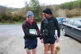
Registration went smoothly and we were “bussed†down to the start. There were about 30 of us in total and I recognised a few of the usual suspects from previous encounters. There were a couple of discussions about which of the two routes should be taken up to Lug as the fire road forked in the first k. Wiser heads then mine seemed to agree on taking the longer route with a more gradual climb. I was not in a position to argue.
Up to Lug
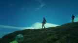
From the off Brian and Zoran opened a gap up the fire road with the rest following suit. Less than 1k into the race two runners took the previously discussed left fork with the rest of the field following the leaders up the right on the long twisting fire road up to Lug. We had a pretty good group of 4-5 for the first 30 mins and maintained a decent pace together until we reached the open mountain. In the distance I could see the leaders already scaling the vertical side of Lug. I decided to follow Alan Ayling on a line a bit closer to the cliffs than a number of the others had taken. Running was not an option at this stage and a zig zagging power hike was about the best I could manage without going completely into the red. I stayed with Alan until pretty close to the top, when we rejoined (loosely) with the other 3 runners that we had run up the fire road. I got to the cairn at lug almost exactly on the hour, had a quick drink and planned my descent.
Descent from Lug
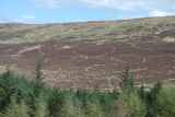
As I left the cairn in Lug I reckoned I was in 8/9th place and reckoned I had a decent chance of picking up a few places on the way down to the checkpoint. However, all great plans etc., as the descent was long, tiring and fraught with perilous ankle twisting boggy holes. Any lapse in concentration meant a stumble, at least. It was energy sapping work but I just about managed to keep within 50 metres of Barry Moore ahead of me, who in turn was in touch with the next group of 3. I maintained this gap until the tree line came into view, and then all of a sudden the horizon flattened out and Barry and the group had disappeared as I tried to take what I thought was a short cut across the mountain. Bad timing on the shortcut, Sheeite! This was exactly what I didn’t want to happen at just the wrong point. I stopped and retraced my steps to the trail, checking the map for bearings. I relocated the mountain path again and followed it to little gap in the trees and over a small wooden bridge, crossed over and took a right down the fire road.
Forest Navigation (or lack of...)
As I descended the fire road through the forest I passed a bunch of hikers walking up the trail so I asked them if they’d seen any runners coming past them, they all nodded. Sorted! Got to one junction but kept trucking through as the turn looked to take me back too high in the valley. I then got to the next t-junction, the left went gradually downhill and the right went gradually downhill, hmmm... I consulted the map and had a look around to see if I could spot any other runners, negative. Consulted the map again and decided that, based on where I thought I was, I should take a left. I had thought wrong! On the way down the long fire road I started hammering out a few ks at a decent pace, happy that I’d either taken the correct turn, or a better one, and confident that I was catching some of the runners ahead ( ks 15/16&17 all fell into this category). Towards the end of the descent I started getting a little anxious. I’d been descending quite a while without any sign of the main road and when a few Wicklow way markers started appearing my previous confidence disappeared quickly. Eventually the twisting fire road came out on the main road. I looked across the road and the tree line was above my head, so what did I do? Yep, I listened to my sound advice from earlier in the day and went.... downhill!.... “Go figure†as the yanks would say! But a tired mind/body doesn’t always make sensible choices (clearly)! I ran for a minute or two down the road until I was completely below the tree line and I could see the whole of Fananeirin over my right hand shoulder, ah balls! A car went past and at that stage I felt like flagging them down for a lift, but resisted and started to walk uphill back up the road to where I now knew the checkpoint was located.
Fananeirin Ridge & Checkpoint
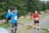
As I came into view of the guys at the checkpoint there was a good bit of laughter as they rightly wondered where I had come from! I nabbed a handful of sweets, a banana and a mandarin (thanks Mick!), and joined forces for the climb up to Fananeirin ridge with Aidan who had hit the checkpoint at the same time. I power hiked to the top of the ridge and jogged slowly on my now very tired legs across the top of the next hill and over to the track at the bottom of Croaghanmoira. I noticed others had tried a more direct route, avoiding the intermediary peak, but all that crossed my mind when I thought of that was boggy tiredness, so I stuck to the trail. At the bottom of the track I crossed paths with Alan here who shouted “feels great to be at this stageâ€... ba*tard!
Croaghanmoira.
The hike to the top didn’t take too long though, and once I checked in with the two marshals at the top (fair play guys, it was Baltic up there!) I knew I was pretty much home and turned around and took it fairly easy coming down the hill. Once I hit the trail at the bottom of the hill I had a quick look over my shoulder to see if anyone was trying a late-in-the-game cheeky overtaking manoeuvre. Thankfully the coast was clear so I cruised/wobbled back to the finish without worrying about mustering the energy for a heroic sprint finish!
Post Race Thoughts:
Despite my cursings in the immediate aftermath of the race about adding 2k and an additional 100metres or so of climbing versus the optimal route, I really enjoyed it. Getting lost in mountains that I don’t know that well, and finding the right route again (eventually), is part of what I love about these unmarked longer routes. There’s a great sense of adventure and camaraderie too. I can’t wait to get lost again!
Thanks to all the marshals and volunteers on the day, these can be long cold days in the hills.
Route data:
http://app.strava.com/activities/52277344
Distance: 24.1km
Elevation: 1,281m
Moving Time: 02:52:42