
Nav challenge 2 - Croghan Mountain
Forum Messages
| Author | Date | Message |
|---|---|---|
| Mick Hanney | Aug 15 2014, 11:58am | A map will be provided for this route. The map won't offer the same level of detail as in other nav challenges as the mapping data for Croghan just isn't there. We have put together a map which uses google openmaps and the outdoors view from http://veloviewer.com/mapFlipper, which has been added to from surveying runs around the hill, so more detail has been added. This combination gave a better level of detail of trails than were available from the OSI map. A map sample will be uploaded so you get the idea. I'd recommend this event as its a chance to take in what would otherwise be a rare IMRA visit to this hill, which has so much to offer. |
| Paul Smyth | Aug 15 2014, 2:18pm | Setanta have an orienteering map of the area. Last version I have is dated 1987 but at 1:15000 it's likely the most detailed cartography of the area. Angus may be able to say whether they have anything more recent. |
| Mick Hanney | Aug 15 2014, 4:56pm | If such a map was available that would be great. I daresay quite a bit could have changed on the ground since particularly with deforestation and new forest emerging. As my survey runs into cul de sac trails have shown :-) |
| Angus Tyner | Aug 15 2014, 5:56pm | Bike O event 2004 may have been the last time. The map is 1:15,000 focusses mainly on the forestry with the summit just on the map. I'll be getting the Setanta lap-top soon and will see if the survey covers more of the western area as well. Mick I'll drop you an email |
| Mick Hanney | Aug 16 2014, 1:33pm | Thanks Angus. hanneymick at gmail.com |
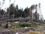
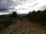
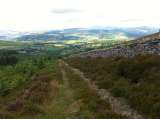
| Mick Hanney | Aug 17 2014, 10:45pm | Some photos added to give a sense of the terrain and the views to be enjoyed. Also, a high level summary OSI map. Start/Finish will be from the Old Wicklow gap, The Gap pub to be exact. Problem uploading some photos which go into the wrong orientation, so hold your screen sideways for a few of them :-) |
| Mick Hanney | Aug 20 2014, 8:58pm | There is some fresh signage around Croaghan trails, probably for use with a 4x4 event who use the hill from time to time. Various letters of the alphabet are signed at various junctions. This signage is not relevant for our Nav event so please ignore. There is plenty of parking space available at the Gap pub but if you are travelling down from Dublin please see if you can work out some carpooling. |
| Mick Hanney | Aug 24 2014, 10:37pm | A subset map sample of an early draft of the Croghan map is uploaded to give an indication of what you can expect. A full version will hopefully include the additional trails which weren't on the original map, in a similar style to the original map (instead of my edits). In any event it will be the same map for everyone on the day :-) The orienteering map wasn't a runner as it was only a portion of the hill and was too dated. |
| Regina Kelly | Aug 25 2014, 4:16pm | Hiya, Just wanted to know whether the long course would be closer to the 16km or the 19km? I might do it anyway but just to be prepared. Thanks |
| Mick Hanney | Aug 25 2014, 9:40pm | An IMRA race was held on Croghan back in 2007. Linky here:- https://www.imra.ie/events/details/id/449/ Directions to the Gap pub (for registration / Start / Finish) (Lifted from an IMRA Annagh hill event which also used the Gap pub). OSI Mapsheet 62: T 108 691 Google maps: "Annaghgap". From Dublin: best route is to take the N11 Exit 22 (Gorey/Inch) at roundabout take 3rd exit (Gorey/Carnew/Inch), at next roundabout take 1st exit (Gorey/Carnew), and immediately take next right, going over humpback bridge. Follow this road straight (from here to pub about 10k), through Kilanerin, keep straight on road until it ends at junction, turn right on road for 700m to Gap pub. Alternate Route: to Rathnew, take the exit to Rathdrum. From Rathdrum: drive through Aughrim, then R747 towards Tinahely for 10k, at crossroads take left (instead of right for Tinahely), continue straight for 8k to carpark of The Gap pub. From Gorey: take Hollyfort road for 12k to the Gap pub. |
| Mick Hanney | Aug 25 2014, 9:44pm | The distance ran is entirely down to the route chosen and if nav mistakes are avoided. The best route on the short course is between 9 and 10k. The best route on the long course is close to 16k. On the long course I would advise sturdy grippy trail shoes as the terrain underfoot is very mixed from trail, to muddy to rocky - a bit of everything really. |
| Mick Hanney | Aug 26 2014, 1:45pm | I recced long course today and it measured just over 18k with 800m of climb. The route I took was pretty runnable. I hiked a small bit and my total time was just over 2 hrs. There may be shorter, less runnable options. The shortest way isn't necessarily the quickest, as I found this morning knee deep in a bog pool :-) Your feet will get wet if this rain keeps up. There are 2 handy entry points onto the hill from near the Gap pub which will be highlighted on the map. The spirit of the event is competitors finish the race via these trail heads. There is an 'escape' / quicker route home available via public road but in the interests of safety please stay on trails and only use the public road as a last resort. On the long route this morning I encountered 2 trees down across the trail. A bit of bashing through the branches and I was through. |
| Mick Hanney | Aug 27 2014, 7:46pm | The Gap pub do a cheap and cheerful menu for post-race eats. Sambos, soup and the like. Also pizza and a pint if you are not the designated driver. |
| James Curran | Aug 29 2014, 2:22pm | Mick, Is an early start possible? I want to do the short route and get back to Croker for 3PM, if I could start at 10AM I could do it. Just asking. Regards, James |
| Mick Hanney | Aug 29 2014, 2:38pm | Early starts are possible. Myself and Gavan intend being there from 9.30 onwards. I aim to put the controls out the previous evening. |
| James Curran | Aug 29 2014, 4:35pm | Thanks Mick. |
| Farrant Stuart | Aug 29 2014, 5:36pm | Hi All. Does anyone have space in their car leaving from Dublin? Stuart |
| Mick Hanney | Aug 29 2014, 7:24pm | Farrant - there is a car in the carpool if you can get out along the n11 towards Delgany, unless there is anyone else travelling from the city? Please read through the race director's instructions on the event and the forum notes which have useful pointers for the race as to what to expect. The Gap pub serves food so I hope many of you can stay on for some post-race banter. A lot of work has gone into a map for the event so I hope ye make the effort to come down and enjoy the day. |
| Mick Hanney | Aug 30 2014, 5:38pm | We are all set for tomorrow morning. Controls are out waiting for the action. |
| Paul Smyth | Aug 30 2014, 11:32pm | As far as I can tell this map uses non-standard symbology. Can we have a copy of the legend displayed at registration. There is nothing worse than trying to figure out unfamiliar symbols n the middle of an event. Thanks. |
| Mick Hanney | Aug 31 2014, 8:11am | We should be able to assist Paul. Map was only finalised Friday. |
| Paul Joyce | Aug 31 2014, 6:10pm | Well done to Mick and Gavan for all their hard work to make today such a success. The map seemed accurate; very important when you are smashing through forest and heather that the little dotted line then appears when expected. Lots of interesting route discussion afterwards, and it was great to catch up with so many familiar faces again. Must get back into hill running next year, its such a friendly community. Can someone please organise a hill race that finishes with a sea swim? Paul Mahon, job for you there ;) |
| Dermot Murphy | Aug 31 2014, 6:31pm | Paul, Bray Head is the race you are looking for! |
| Paul Joyce | Aug 31 2014, 6:38pm | Great stuff Dermot, so for 2015 Bray Head race: up and down the Head, into the sea, finish line is on Killiney Beach, you heard it here first folks ;) |
| Stephen Bailie | Aug 31 2014, 8:47pm | Well Done Mick, Gavin and Co. Tough event physically (for me anyway after 10 pints last night) Map was 100% spot on. I think scatter series is the way to go. Cuts out the sheep syndrome. Once again great event guys. (Glad I chose this over Croke Park today). |
| James Curran | Aug 31 2014, 9:25pm | Amen to that Stephen, wish I had done long course instead of going to Croker after short course. Thanks Mick, Gavan and Brendan for a great run. Up the Dubs. |
| James H Cahill | Sep 1 2014, 10:41am | Thank you Mick and Gavan, Brendan, Declan, Dace and other helpers for a great day in the hills yesterday. The huge amount of recce survey work carried out by Mick and mapped by Gavan really paid off with a great route. The day was made all the more enjoyable being in unfamiliar surroundings. Thank you all and well done everyone involved. |
| Gavan Doherty | Sep 1 2014, 12:17pm | Hi all, Thanks to all those that made it down yesterday, but particular thanks to all the volunteers (Dace, Declan, Brendan, Mick). It was the perfect start/finish location (pizzas & pints options were popular) and the weather was fantastic. Results are below. I'll get a version to the IMRA webmasters & hopefully when they've recovered they can get them up into the main IMRA results format. I've also uploaded some photos, including the map that we used: https://www.imra.ie/photos/view/id/88739/ It was a collaboration between Mick, Google and myself, so we knew it had some quirks which was a challenge for some Long course people. For comparison the OSi version is here: https://www.imra.ie/photos/view/id/88069/ and the version available on Google or Strava or something is here: https://www.imra.ie/photos/view/id/88698/ LOST PROPERTY: someone left behind a rucksack. Ger Power has it. contact her on O87 795 7one46. Results: Short Course: Keith Fitzsimmons 81:24:00 Ruairi Sugrue 92:15:00 James Curren 107:42:00 Nora Lalor 117:35:00 Paul O'Grady 130:36:00 Theresa Doyle 131:14:00 Hilary Jenkinson 131:37:00 Santina Doherty 132:18:00 Jane Walsh 137:52:00 Anne Hodge 140:10:00 Thomas Galvin 140:16:00 Alice Clancy 140:48:00 John Lawrence 150:34:00 Long Course: Conor Short 103:43:00 Colm Hill 112:28:00 Ruairi Short 117:27:00 Paul Mahon 121:24:00 John Bell 122:55:00 Niamh O'Ceallaigh 135:10:00 Torben Dahl 138:44:00 Eoin Syron 143:59:00 Brian O'Meara 144:09:00 Philip Brennan 144:12:00 Paul Smyth 146:53:00 Roisin McDonnell 151:00:00 Dallas Baird 151:17:00 Paul Joyce 151:18:00 Sam Scriven 153:13:00 Alison Campbell 156:35:00 Daniela Boehm 159:24:00 Raghnall O'Donoghue 162:07:00 James Cahill 168:36:00 Joe Lalor 172:28:00 Kevin O'Riordan 173:52:00 John Condon 176:22:00 Hugh Kinsella 179:27:00 Eddie Cousins 182:49:00 Regina Kelly 192:03:00 Colin Walsh 196:08:00 Eileen Walsh 198:31:00 Jason Dowling 204:02:00 Stephen Bailie 205:01:00 John McCann 220:26:00 Ger Power 228:53:00 Maike Jurgens 233:35:00 Caitlin Bent 278:55:00 Don Short 186:22:00 (DNF) Brian Sugrue 145:02:00 (DNF) |
| James H Cahill | Sep 1 2014, 2:49pm | Race report up |
| Mick Hanney | Sep 1 2014, 8:06pm | Great report James. A fuller set of photos added from around the mountain. |
| Theresa Doyle | Sep 1 2014, 8:27pm | Thanks to everyone for all the hard work organising such a great event, particularly for beginners like myself. Much appreciated. |
| Anne Hodge | Sep 2 2014, 5:55pm | Yes, thanks Mick and Gavan for organising a great run. Despite going wrong and adding about 4k to the short course - I really enjoyed it. A swim at Brittas on the way home made it the perfect day ! |
| Maike Jürgens | Sep 3 2014, 6:48pm | race report up. my suspision is that some sort of clockwise route was faster for some reason. would be interesting to find out if and why |
| Mick Hanney | Sep 3 2014, 10:00pm | The winning routes appeared to be clockwise alright. That said, I have a preference for taking the route in the anti-clockwise direction. The 'shortcuts' to be had between controls weren't always the fastest. The longer trail connections were pretty runnable throughout. I have a preference for the runnable sections in the anti-clockwise direction too e.g. the fenceline down from the summit to 165 is very nice. I tried a section of forest this evening that people had mentioned running on Sunday and the going was horrible (going uphill anyway). Much faster to take the longer trail loop in my view (between control 165 and 167). I'd be interested in how one goes about surveying a map as this was my first introduction to assisting the compilation of same. I ran a lot of trails in the prep for this event but I only ran a minority of the route options that people magic'ed up on the day :-) There is a world of trails on the hill that remain to be mapped properly. |