
Carrot & Stick
Authors
Unknown
28 November, 2009
<a href="http://www.imra.ie/ad-hoc/NC.htm">Current NC Table<a/>Race results from Carrot and Stick
1. Aonghus O?Cleirigh 1.54.13
2. Gerard Dillion 2.01.59
3. Marcus Geoghegan 2.06.46
4. Phillip Brennan 2.09.36
5. Fergal Reid 2.27.57
6. Justin Rea 2.34.20
7. Melanie Spaeth 2.34.23 1st F
8. Andrew McCarthy 2.46.54
9. Dave Weston 2.54.49
10. Barry Tennyson 3.07.48
11. Isabelle Lemee 3.08.53 2nd F
12. Mick Kellett 3.33.59
13. Eithne McShane 3.45.12 3rd F
14. John Shiels 3.45.12
15. Moire O'Sullivan 4.04.07 4th F
16. Caitlin Bent 4.25.58 5th F
17. Conor Murray 4.25.58
Charlie O'Connell, retired due to injury.
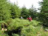
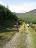
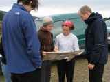
On Sunday August 20th, eighteen competitors took part in round two of the three-race Navigational Challenge series in the Slieve Maan/Corrigasleggaun/Fananierin area, south of Drumgoff in County Wicklow. The first challenge - working out the locations of the five control points from the grid references - automatically spread the competitors out along leg one, an uphill run along a forest road followed by a flat section on a grassy ride. Most took roughly the same route on this section, something that cannot be said of the next two legs; indeed in the pub afterwards I could not find two people who took the same route along the second and third sections, a testament to Joe Lalor's excellent course planning.
Most managed to find the muddy ride leading north-west away from the first control towards the east side of the Carrawaystick ridge, but others chose an alternative route that lead them to the west side of the ridge. At this point some followed a long road route to the next control at Kelly's Lough, others followed a more direct north-westward cross-country route contouring around the ridge, a couple crossed over the ridge from south to north and others did some variation on these options. Leaving Kelly's Lough the same variety of route choice was seen with some going back the way they came and others deciding to go back a different way, often because they presumed that someone else's outward route was better.
The next control was approached by some runners from the west along a rough river valley, by others from the south along a road, some came from the north through trees and one intrepid adventurer managed to approach from the east through a jungle. It seems that the first four runners were within a minute of each other at this control but most did not see the others. The remaining three sections involved little route choice but did involve a long downhill forest road run along the Cloghernagh valley to the lowest point on the course, immediately followed by a relentless uphill climb to the Fananierin ridge and onwards up to the unnamed hill at its southern end. This ascent was the scene of an epic battle between Justin Rea and Melanie Spath, with Melanie leading Justin all the way to the top but unable to hold off Justin's challenge on the final downhill, losing by three seconds but still winning the women's race.
My race length was 15.8km, but depending on your route choice it could have been up to 19km. The total climb was 720m, 40% of it in the last 4km. Often the longer road routes were better than the shorter cross country options, but by no means always and no real consensus emerged about which overall route was best. It is worth noting that the race winner, Aonghus O'Cleirigh, was one of the last to leave the car park, showing that careful grid reference work and advance route planning pays off. The runner who was first to leave the carpark, and who was first back, and who will not be named here, missed one control and had to go back out to complete the course, thus dropping about 45 minutes.
Thanks to Paul Nolan for officiating, Joe Lalor for course planning and control placement, and to Kevin Carroll and Joe Bent for marshalling. The weather was a pleasant 20 degrees, cloudy, with no rain or wind.
<a href="http://orienteering.ie/wiki/doku.php?id=mapping:gps"> An animation of my route can be seen here<a/>
<http://orienteering.ie/wiki/doku.php?id=mapping:gps >
NC2 COURSE
Race 2 Navigational Challenge Carrot & Stick 17.0km 500m
The following positions must be visited in order
1. Start 087876
2. Track/Ride Jn 083889
3. Lake SE end 060907
4. River Junction 080902
Cut Off: If not crossed Military Road by 15.30 return to start
5. Fence Junction 108888
6. Summit 094874
7. Finish 087876