
Nav Challenge 3
Authors
pun run
14 October, 2024 - Maike Jürgens
On Alice' request, here is a report for Nav3. She requested it when we had a great pun post race but now, none of us can remember the actual pun but we'll see how many are hiding in this report. In our household these are occasionally referred as 'Maike jokes' as I make them unintentionally a lot of the time (they may need to be called 'Mike' jokes recently, as I think the increasing use of type correcting and autocorrect not knowing the name 'Maike' means I get called Mike quite frequently).Negotations as to who got to run the Nav challenges wasn't very tough this year, Mike got first dibs. For Nav3, we had babysitters so were both able to go. Following a slew of birthday parties, cake making, jelly preparation and slime mixing, I was looking forward to the nav challenge, it turns out my brain was really looking for a break.
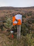
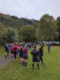
We reached the carpark in good time, signed in, did the map corrections. A lot of banter when we noticed not all 3 maps included the same map corrections and we had to do corrections to the map corrections. Also, some speculations were had as to the importance of the invisible ruin and the gap in the deer fence. A quick scout of the steep track towards Camaderry and it was time to get started. Joe was very insistent on everyone listening carefully to his race briefing. We all showed our jackets, I stumbled over the mention of holes on wet ground but hadn't quite heard where it was - oops.
We got to pick the papers and I was a little confused we were allowed to start marking the maps immediately as I was used to 'don’t turn it over till I say so'. Sitting next to Stuart I started marking my map and my brain was not cooperating. I couldn't figure out grid refs. What is going on. Where is this earthbank junction, there is soo many here. Stuart marked the boots. Will I go with that? Do the others, come on now. Joe shouting about the master map while others who also thought it was an 11.00 start keep signing in (clearly we are all incredibly diligent in reading the information on the website, I did think it was 11 but Mike corrected me to say 10.30, phew). I didn't think checking the master map was fun if part of the fun is marking the map but this would come back to haunt me very quickly. Up the steep track, slipping and sliding meeting Brendan and Joan. Off into the ferns, surely those earthbanks must be here somewhere. See Mike on the track, marked wrong. Seems a lot of us did. Should have checked that master map, a lot of time and energy wasted but I do find the control eventually. Then onto the forest remnant corner. Steep ground ahead, look at map, look at rocks, look at map, look at heather, see people move uphill from forest corner that's where it must be, tie laces, find control, tie laces, eat jellies, drink water, stumble uphill, find path to Camaderry, find earthbank, should really follow track further but why on earth did I decide to take a bearing for the crag from here? Only my brain knows. Stumble through more heather, enjoy views of the lake, forget about racing. Tie laces. Meet Joan and we discuss where the crag should be, move along a bit and see crag a good bit above us. Oh man, this really isn't my day. Get to (more like stumble) to control, punch, meet some of the runners going the other way. I think their side must have been easier. Tie laces (triple knot!), meet Andreas and Anne. With Joan we make it to control 8. Andy says go low else you'll miss it from this direction (much lower and we'll fall of a cliff - physically and energy wise I'd say). We debate if we overshot it but Joan spots it. Then down the hill.
Tie laces again. I really should have put tape and really should have put on my other shoes because with the wet these ones are about 2 sizes bigger now and my feet are slipping and sliding inside the shoe. We make our way down to the bridge. Nice chats. Boom - my left leg finds a hole, outsch. I guess this is where Joe said the holes were. I move on and don't want to worry about it. At the bridge, Andreas shares a wipe and I decide against sitting down and going home.
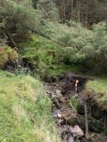
The next control at the crag isn't so bad. We then move over the ridge (would the other route down the spinc have been faster? I hindsight yes). We can't find the trail but the trees are mature enough to just make our way down to the fireroad apart from the last little bit that is very wet. AT the fireroad, have to retie laces for the umptieth time. Find the trail/stream control (well hidden in the depth of the stream) and attempt a jog to meet the wicklow way. Make our way past the long uncrossable deerfence and exchange a few Rogaine stories about fences. Find a control but agree it must be on the shortcourse.
Minor confusion on which path leads to the ruin(ed) control but we make it. Andreas suggests the trail around rather than direct line to the last control which is probably wise considering my leg has been stinging for the past few hours now. We make our way around and up to 6. it isn't there. Hang on a minute. The stream curves right, what is that white thing there is that a sheep or deer or a control? It is the control, get there, punch, head down. Stick to the trails. Make it to the finish. That is all tied up nicely now (apart from my laces that need retying at least once or twice on the last 2 km).
Not a great day nav wise or running wise or anything, maybe type 3 fun even. Never mind. I am having a bad run of it after going wrong twice in a marked race during the women's nav challenge never having gone wrong in about 170 races .. Apart from the wicklow way and a nav challenge years ago.
Some lovely TLC from Alan on the scratch (did you know warm water is soothing on it rather than stinging? Must remember for the future).
Thanks Joe for letting us see some parts of Wicklow we may never want to see again and experiencing others that were actually quite beautiful.
Nav Series 2024
14 October, 2024 - John Bell
Nav 1, Baravore aka Stuart Scott Special.8 controls any order, and i expected Stuart would take us off the beaten track with lots of rough stuff.
What order to go for the controls took a bit of figuring out. I started off going on an anti-clockwise direction. By the time I got to the second control I had changed my plans about 5 times. There was lots of choice in trying to decide between the shortest distance, least climb, most runnable ground, and approach to the controls. The weather was good with little cloud, so finding the controls once in their proximity wasnt too hard. I had Mike and Paul for company until after our second control. Mike then disappeared in a different direction. Paul and I took slightly different routes to our third control at Furry Rocks (EastWest are great maps for details including placenames) Paul was slightly ahead and I was stalking him as we headed off to our 4th control at Three Lakes, we got there together wondering where Mike went. Our 5th was a plane wreck. I took the high route, Paul slightly below, with two sets of eyes better than one. After the plane wreck there was a nice decent down along the river, where I decide to try push on a bit. I picked up the 6th control at the river bend, and set off on the long slog up to my last control on top of Strands of Baravore. As I was climbing I could see Paul but not too far behind, but I knew he still had to pick up another control on the way back, which meant his route choice was limited. Lots more bog to cross the Guttery of Imaal Gap, before finally reaching the summit control. The inotial descent from the summit was a beauty. Bouncy and grassy but not too lumpy. I took the main track back via Fraughen Rock Glen. Once down onto the forest road I tried to keep running, but it was more of a plod after all the bog trotting had sucked the energy out of my legs. Back to finish where Staurt and his team has ice creams and cold beers waiting, where we could soak our legs in the river and share stories of our adventures.
https://labs.strava.com/flyby/viewer/#12290893845?c=gc7mmrcu&z=D&t=1cqkFh
Nav 2, Shay Elliot, aka Liam's lines in the rough.
In the lead up to this race the forecast was not good, with gale force winds and rain predicted. It ended up not too wet or windy, and the cloud stayed mostly high. Liam had nine controls arranged with lots of traps in waiting. Again free route choice, so choice was clockwise or anticlockwise, and a few options on what order. On race briefing there was some information about control 9. I should have paid more attention. I got the control sheet, marked up my map, and decided to go anticlockwise. Set off for my first control and kept studying the map on my way up the track. This time I made my mind up on the route quickly, so just doubled checked that I had marked the map correctly. From experience, there is nothing worse than marking the map incorrectly. My first control was straightforward along a forest ride. Second was well hidden beside a well hiden boulder in Ferny Hallow. I was visible from a distance in the other direction. The third was a plod up to Braigue Mtn. Fourth was down into the Forest and through some rough stuff, but I spotted the control at the stream junction at Boleylug quickly enough. Next was the summit of Mullacor, where i opted for the longer way round to avoid more dense forestry. The descent off Mullacor was one of the few bits that was good for running. I descended to the stream source, but which source took a bit of zig zagging. I passed a few going in the opposite direction, including Alan who was complaining about the ground. Here it was nasty with long tufty grass. I managed to fall a few times, but lucky no one was watching and the ground was soft. Next was up to Ballyboy where the control was in the middle of a fire break in the forest. It looked straightforward on the map but with recently felled trees it was hard to figure out what was a fire break or a route made by a track machine. The cloud dropped here to make it a bit more challenging. After a bit of wandering around I spotted some runners tracks, which help show the way. I descended ducking and sliding down through the forest to the infamoous Control No. 9 Looking at my map, was in the upper, middle or lower track? I should have listened more carefully at the briefing. I checked the upper first, not wanting to descend unnecessarily. Nope. Then descended to the middle, or at least that were I thought I was, but the tarmac road below looked too close. After a bit of back and forth I found the middle track and control, and then it was the slog back up. The last control was a good way round on runnable tracks but with one last big climb up thehill with no name (one B Dalby missed?). Punched at the control and plodded back to the finish. After 3+hrs for 20k and 900m ascent. I was wrecked but first back on the long course. Others arrived back with plenty of stories about various mis-adventures. It was a tough challenge and that showed by the small numbers who managed finished the long. Paper maps turning to mush making it impossible for some.
https://labs.strava.com/flyby/viewer/#12535123098?c=gc7mr64f&z=C&t=1c_IO3
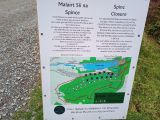
Nav 3, Glendalough, aka Joe's Rutting Round.
It was a nice chilly morning, but the cloud was high and only a light breeze. Joe gathered us around for the race briefing. I was listening intently, not wanting to miss any important details. Joe's map corrections had everything needed. The pre-race info told us 8 controls and option for either direction. Mike Jordan reckoned he was going up Camaderry first, so I decided to go the opposite. It makes it more interesting wondering how others might be doing. No sign of Paul Mahon. My first control was on the side of Derrybawn Ridge, with an embankment providing a useful handrail. The next two controls were fairly straightforward with a bit of route choice between more direct but rougher terrain or longer more runnable ground. I went with the more runnable way. Up on to the open mountain, and i remembered Joe's advise about the Stags in rutting season. Give them plenty of space and they won't be a bother. The only problem was the hill was teaming with deer. Some of the big Stags were not moving and looked too intimidating to go too close to, so finding a route that avoided the biggest Stags part of the route choice. It was like running through a mine field to get to the crag at Lugnafosta. I might have cleared the way a bit for anyone else following. I got to the bridge at roughly the half way point, and still no sight of anyone coming in the other direction. The climb up to the next control was slow going and i was being particularly careful following the map. A big boulder in a boulder field could be hard to spot. When I got to the top of a small hill at Murphyas Hallow I stopped to scan and to try figure out where to go. From here I could see the control about 500m away and 4 runners leaving it. Easy. No hassle in this direction, but for those going in the opposite it was well hidden. I passed Mike and Paul, who arrived late thinking the start time was half an hour later. Mike said i could help myself to his birthday cake if i got back before him. From here I contoured round, following a few deer tracks, which made the going much easier. Again the control was visible from a good distance off. If it was in low cloud, finding these controls would be another storey. Over the hill and again through a minefield of big stags trying to keep a distance. Earlier i had double checked the control coordinates and description and made a correction. Otherwise i would have been in the forest below scratching my head. I found the control without any glitches. One more to go. Down the nice grass path, but slowing up when nearing where I expected the control should be. It would have been easy to over run it when flying down. A well trampled path through the bracken showed I was in the right place at Dalty's Walls. For the final descent I found a nice way down through the trees that was fairly direct, but minimised bashing through too much bracken. Back to the finish after 14.7k and 840m ascent, where Joe & Nora had plenty of sambos, cake and tea to recover and share stories.
https://labs.strava.com/flyby/viewer/#12645829164?c=gc7mrpbe&z=D&t=1d2vEz
Thanks again to Stuart, Liam and Joe for another fantastic and challenging nav series