
Nav Challenge 1 - Comeraghs
- Description:
- Comeragh Nav Challenge
- County:
- Waterford
- Date:
- Saturday 30th August, 2025
- Time:
- 12:00
- Climb (m):
- 600
- Distance (km):
- 15.00
- Short Course Distance (km):
- 0.00
- Event Difficulty:
- 9 (3,3,3) - Difficult Terrain, >500M ascent, >10Km
- Race Marking:
-
 -
Route not marked
-
Route not marked - GPS Allowed:
- No
- Leagues:
- Navigational Challenge
- Mandatory Kit:
- Level C - Advanced
- Waterproof jacket with integrated hood and taped seams
- Hat or buff
- Gloves
- Whistle
- Charged mobile phone with emergency number stored
- Foil blanket, bivvy bag or equivalent
- Waterproof full leg cover
- Means to carry a minimum of 500 mL water
- Emergency food
- Map of route/area
- Compass
All runners must bring the above items to the race. The actual kit to be carried during the race will be finalised on the day, depending on conditions etc., and clearly advised at Registration.
You should also have the means to carry all the kit in case required.
Failure to have the required items may lead to you being denied entry to the race, or disqualification. Random checks may be carried out.
- Getting There:
- Powers the Pot Camping and Caravan Site, Harney's Cross, Via. Clonmel, Co. Waterford, E91 F782 https://maps.app.goo.gl/4j6NYU2Y8HskEY39A
- Juniors:
- As this is an unmarked course on open mountain (>10km), junior entries (<18 years) are not permitted (section 5 IMRA Competition Rules).
- Early Start:
- There is no early start for this event.
- Organisers Instructions:
-
OVERVIEW
Please note that participants should be comfortable using a map and compass to navigate in upland environments and poor visibility.
As this is a navigational 'challenge', it is for map, compass, and any other old school ingenuity you can muster!
It is not permitted to use GPS/smartphone/watch or any other electronic navigational aids.
However, if you get lost you are more than welcome to use GPS to find your way back, provided you declare it at the finish line. You will be credited with a 'non-competitive' result.The LONG course option can run 15/16km with 500-600m elevation.
The SHORT course option can run 8/9km with 300-400m elevation.
Please note that these distances and elevations are approximate and provided only as a rough guide. You might find yourself covering a little less, or a lot more(!), depending on your route choice.The course will close after 4 hours, so all participants should return to the finish by 4pm.
You will qualify to complete the LONG course having located and stamped your card at 9 controls.
You will qualify to complete the SHORT course having located and stamped your card at 5 controls.
Any mandatory controls and out-of-bounds areas will be outlined before the start.Participants must bring their own map and compass (further details below; see event photos). It is advised to bring sufficient food and water for the event duration as there are no on-course aid stations.
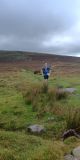
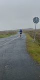
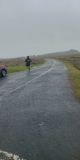
The course is on open mountain, covered mostly by grasses, heather, peat and some rough trackways. There will be short sections of public road and designated crossing points which all participants must adhere to.
Unfortunately, the event is NOT suitable for juniors (<18 years) as this is an unmarked course in an open mountain environment.
Please keep an eye on the Forum in the week leading up to the event. And for those new to the Nav Challenges, a first timer's briefing will be held by the registration desk at 11.30am to outline the day ahead and address any queries.
Please see full event details below:
WHERE?
Parking and Registration at 'Powers the Pot' camping with the start/finish close by. There are also toilet facilities here.
https://maps.app.goo.gl/4j6NYU2Y8HskEY39A
52.3286, -7.6241We ask that all participants please drop €2+ euro in the bucket as a contribution toward the parking and facilities that are very kindly being made available to us. For parking please follow volunteer directions on the day.
Tent and Campervan pitches are available here should anyone like to make a weekend of it. This is a wonderful campsite in a beautiful location. Please see their website for further information and booking: https://www.powersthepot.com/
WHAT TO BRING?
All Mandatory Kit C items (details above). A decision will be made on the morning as to what items are to be carried during the event.
Please note that there are no aid stations on the course so it is advised that you carry sufficient water/food.Please bring your own copy of 'Comeragh' by EastWest Mapping (1:25,000). This can be purchased online directly from EastWest at https://eastwestmapping.ie/product/comeragh/, or copies can be found in some outdoor stores and bookshops.
While there are other maps at various scales available for this area, you will be at a considerable disadvantage not having access to an EastWest map.If you are using a non-laminated map, some form of protection for your map is essential. Even if the day is dry, general wear and tear with repeated drops and an occasional stream or bog crossing will compromise the legibility of this vital lifeline! While you can get specialist map sleeves/protectors, a large zip-lock also works wonders.
A pen/pencil/marker to mark your map and any notes you wish to make.
A standard baseplate 'hiking' compass that allows you to overlay/align a map is required. These can be purchased in all outdoor stores. Please note that small compasses often found on key chains/bags/etc. will not be fit for purpose.
Please bring your own cup for refreshments afterwards.
THE NAV CHALLENGE FORMAT
This is the first Nav Challenge event to be held in Munster in recent years and will follow the long-established format of the Leinster Nav Challenges. It is the first of four events in this year's Nav League, and you will find information about the League and the other Nav Challenges to be held in Leinster during September and Octoberhere.
Participants will be supplied with a list of map coordinates and (possibly cryptic!) descriptions for the designated controls, or waypoints, on the course. You will locate these points on your map and proceed to plot your path around the course. This is where the real challenge lies - what is the optimal route to each of these controls that best suit your strengths on the hills?
For those looking for some peace of mind - a master map will be made available 5 minutes after the start showing all control locations. You can use this to check against those you identified to ensure everything is in order before you head off. Please remember that no electronic devices are permitted during this event so you will rely only on your map and compass to work your way around the course.
The controls will be marked with orange/white orienteering kites, each holding a punch with a unique pattern that you will use to mark your card. After you visit the required controls, punching your card at each, you will return to the finish point for rest, refreshment, and some in-depth discussion on the variety of 'interesting' routes chosen by everyone...where it all went right...or wrong! Remember that your card is key - cling to it for dear life! If you cross the line without it a 'non-competitive' finish awaits :(
The coordinates will be in Irish Grid format, comprising a 3-digit Easting (E) and Northing (N) value. You will use the numbered grid printed on the map to determine these locations. This coordinate information will be sufficient to get you to within 100m of the control. Please note that the orange/white kite will not always be readily visible so some further exploring of the area may be required. As an example, the coordinates for trig on Lacknafrankee = 235/181
An air of mystery around the exact area will persist. But in the days leading up to the event, the SW (bottom-left) and NE (top-right) corner coordinates for the area will be made available (see Forum). Some like to trim/copy/fold or otherwise customise their maps to focus on this. And I'm told that the real experts can commit the spaghetti-like sprawl of contours and variety of other topographical features to memory at a mere glance!
THE COURSE
The course is entirely over open mountain and commonage. There will not be a need to cross fences or walls (you will have gone astray if you do!).
Accessing private land will not be required and is not permitted under any circumstances.
You can expect to meet plenty of sheep on your travels and we ask that you make every effort to avoid causing undue distress to animals.
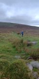
Ground cover is primarily of heather and peat, but you may encounter an occasional worn path/track and some short sections of road. Current conditions are dry and wonderfully springy, but this can quickly change! Favour grip; Mother Nature will provide the cushion.
The area itself is not exceptionally high, or remote. If the weather is kind and the sky stays high, the going should be smooth enough. If the mist descends, however, we are all aware of the challenge posed when finding our way in the clouds. Remember that there will be no course marking - the reassurance we often find in a red IMRA arrow pointing the way will be lacking here. The orange/white kites and an occasional encounter with a fellow navigator or sheep will provide your solace this day!
The real beauty of the Nav Challenge is that it provides the full immersion experience. Having carefully plotted and plodded all afternoon with head held high in search of the next landmark, you will come to see and sense this extraordinary landscape as never before!
Volunteers (Non-Running)
You need to have done 2 non-running volunteer roles in a calendar year to qualify for end of year prize
Volunteers (Running)
Check with race director if they have a need for people volunteering and running. Race directors need a minimum number of people available throughout the race to make the race work so non-running volunteers are preferable. While it can be helpful, volunteering in a volunteer and race capacity does not count towards qualifying for end of year prize
Carpool
| Driver Name | Location | Passing Through | Departure | Seats Available | Seats Accepted |
|---|---|---|---|---|---|
| Marian Shinnick | Douglas, Cork | Return uncertain - map skills pending... | 09:45:00 | 3 | 0 |
| Mike Jordan | Ballycullen | Red Cow, N7, M9, N76 | 08:30:00 | 2 | 0 |
| Cormac MacDonnell | Carlow | 09:45:00 | 2 | 0 | |
| Cormac MacDonnell | Carlow | 09:45:00 | 2 | 0 |